


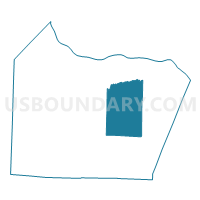
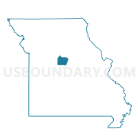
Clarks Fork Voting District, Cooper County, Missouri
About
Outline

Summary
| Unique Area Identifier | 607654 |
| Name | Clarks Fork Voting District |
| County | Cooper County |
| State | Missouri |
| Area (square miles) | 52.66 |
| Land Area (square miles) | 52.63 |
| Water Area (square miles) | 0.03 |
| % of Land Area | 99.94 |
| % of Water Area | 0.06 |
| Latitude of the Internal Point | 38.84851670 |
| Longtitude of the Internal Point | -92.69234190 |
Maps

Graphs
Select a template below for downloading or customizing gragh for Clarks Fork Voting District, Cooper County, Missouri


Neighbors
Neighoring Voting District (by Name) Neighboring Voting District on the Map
- Boonville Rural No. 1 Voting District, Cooper County, MO
- Boonville Rural No. 3 Voting District, Cooper County, MO
- Boonville Rural No. 4 Voting District, Cooper County, MO
- Kelly Voting District, Cooper County, MO
- Prairie Home Voting District, Cooper County, MO
Top 10 Neighboring County Subdivision (by Population) Neighboring County Subdivision on the Map
- Boonville township, Cooper County, MO (10,371)
- Saline township, Cooper County, MO (840)
- Kelly township, Cooper County, MO (716)
- Prairie Home township, Cooper County, MO (682)
- Clark Fork township, Cooper County, MO (655)
- Palestine township, Cooper County, MO (396)
- North Moniteau township, Cooper County, MO (255)
Top 10 Neighboring Unified School District (by Population) Neighboring Unified School District on the Map
- Boonville School District, MO (11,591)
- Prairie Home R-V School District, MO (1,387)
- Cooper County C-4 School District, MO (933)